
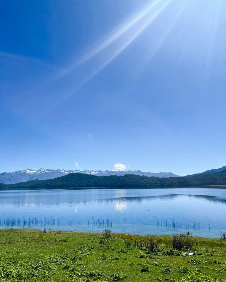
Rara 7 Days Tour
US $499

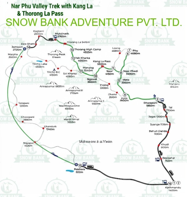
This trek stacks three of the Annapurna region’s biggest challenges into one continuous route: a restricted Tibetan-influenced valley almost nobody visits, a remote 5,300m pass, and one of the highest lakes in the world, followed by a second demanding crossing most Annapurna trekkers never even hear about. You’ll leave the main Annapurna Circuit at Koto and disappear into Nar and Phu — walled villages, working monasteries, and stone houses that have barely changed in generations — before crossing Kang La Pass back toward Manang, detouring to the turquoise waters of Tilicho Lake, and finally exiting west over Tilicho Pass (also called Mesokanto La) down to Jomsom, rather than following the crowds over Thorong La.
If you’ve done the standard Annapurna Circuit and want the harder, quieter, more remote version of this region, this is that trek.
Nar Phu Valley — The Hidden World Nar Phu only opened to foreign trekkers in 2003, and it still feels like it. Phu Gaon is a walled village of stone houses stacked into the hillside, with an ancient monastery watching over the settlement. Nar, a shorter distance away, has its own distinct character and good views of Pisang Peak. Because the valley requires a restricted-area permit, tourism here has stayed genuinely limited — you’re walking through working villages, not ones shaped around visitors.
Kang La Pass — The First Major Challenge At 5,322m, Kang La is the trek’s first serious test. You’ll leave before dawn for a steep, sustained climb, with snow and ice possible underfoot depending on the season. From the top, views stretch out over Annapurna II, Gangapurna, Tilicho Peak, and Himlung Himal, before a long descent down toward Ngawal and back onto the main Annapurna Circuit trail.
Tilicho Lake — The High-Altitude Reward At 4,919m, Tilicho is genuinely one of the highest lakes of its size anywhere in the world, ringed by Tilicho Peak, Gangapurna, and the wider Annapurna massif. Most trekkers base at Tilicho Base Camp and do the final push to the lake as an early-morning out-and-back hike, taking in the turquoise water and glacier-fed silence before returning to base camp for the night.
Tilicho Pass — The Second Big Crossing This is the crossing that separates this trek from a standard Tilicho Lake itinerary. Also known as Mesokanto La, it sits at around 5,099m, though different operators cite figures anywhere between roughly 5,099m and 5,300m depending on which exact point on the ridge is measured. It’s a genuinely demanding day — steep, rocky, and exposed — connecting the Manang side of the Annapurna region to Jomsom without needing to cross Thorong La at all.
| Standard Annapurna Circuit | Nar Phu + Kang La + Tilicho | |
|---|---|---|
| Route character | More established | More remote |
| Focus | The main circuit itself | Adds the restricted Nar Phu valley |
| Main pass | Thorong La | Kang La, plus Tilicho Pass (Mesokanto La) |
| Villages | More developed | Traditional Nar Phu settlements |
| Overall experience | The classic Annapurna trek | A more demanding, adventurous combination |
Choose the standard Annapurna Circuit if you want the classic route around the Annapurna massif, with well-established infrastructure the whole way. Choose this trek if you want to add the remote Nar Phu valley, a genuine restricted-area experience, and two demanding high-altitude crossings instead of one.
This is not an ideal first Himalayan trek, and it shouldn’t be marketed as simply “moderate” without that qualification. It’s genuinely suited to:
If this would be your first time trekking at altitude, or your first multi-week trek of any kind, this isn’t the place to start.
Mornings in Nar Phu start cold and quiet, frost on the teahouse window, breakfast eaten quickly before the day’s climb. The trail alternates between narrow gorge paths, high suspension bridges, and open, rocky terrain, with villages appearing less often than on the main circuit — each one feels like a genuine destination rather than just another overnight stop. On pass-crossing days, the rhythm changes entirely: a pre-dawn start, hours of steady, deliberate climbing in the cold, and a real sense of relief once the top is behind you. Evenings are simple almost everywhere on this route — a hot meal, conversation with your guide about tomorrow’s terrain, and an early night, especially before Kang La or Tilicho Pass.
This is a long, physically demanding trek — 21 days, two passes above 5,000m, and extended time at high altitude throughout the middle stretch.
Altitude. You’ll cross Kang La at 5,322m and Tilicho Pass at around 5,099m, with Tilicho Lake itself sitting at 4,919m in between. That’s a lot of time spent above 4,500m, and the two big crossings come without the extensive infrastructure and rescue access found on more established routes like the standard circuit.
Terrain. Expect steep, sometimes icy climbs on both major passes, narrow and exposed trail sections in Nar Phu’s gorges, and a genuinely rocky, technical descent from Tilicho Pass toward Jomsom.
Pacing. Acclimatization days are built in at Phu Gaon and Manang — take them seriously. Rushing the schedule on a trek with two 5,000m+ crossings is one of the more common ways trekkers run into real trouble here.
Beyond the scenery, this valley is a genuine living record of Tibetan Buddhist practice. Chortens and mani walls mark nearly every village entrance, and prayer flags strung across passes and rooftops are a constant presence. Monasteries in Phu Gaon and along the route remain active places of worship, not preserved sites — you’ll likely pass monks going about ordinary daily routines rather than performing for visitors. Because Nar Phu stayed closed to outsiders until 2003, and still requires a restricted-area permit today, the pace of change here has been genuinely slow, which is exactly why the culture feels so intact compared to more heavily-trekked parts of the Annapurna region.
Spring (March-May) and autumn (September-November) offer the most stable weather for both Kang La and Tilicho Pass — both crossings are genuinely weather-sensitive, and stable conditions matter more here than on most treks in Nepal. Winter (December-February) brings serious cold and likely snow at both passes, and the monsoon (June-August) brings poor visibility and higher risk on exposed terrain — neither season is recommended for this specific route.
You’ll need a Nar Phu restricted-area permit, an Annapurna Conservation Area Permit (ACAP), and a licensed guide, all arranged as part of your booking. As of March 2026, Nepal removed the rule requiring a minimum of two trekkers for restricted-area permits, so solo travelers can now join with just a guide — though given how remote this specific route is, trekking with at least a small group is still a sensible idea.
Day 1: Arrival in Kathmandu (1,400m)
Day 2: Permit preparation and city sightseeing (1,400m)
Day 3: Drive to Dharapani (1,960m)
Day 4: Trek from Dharapani to Koto (2,600m)
Day 5: Trek from Koto to Meta (3,560m)
Day 6: Trek from Meta to Chyaku (3,720m)
Day 7: Trek from Chyaku to Phu Gaon (4,250m)
Day 8: Acclimatization day in Phu Gaon (4,250m)
Day 9: Trek from Phu Gaon to Nar Phedi (3,490m)
Day 10: Cross Kang La Pass (5,322m), trek to Ngawal
Day 11: Trek from Ngawal to Manang (3,540m)
Day 12: Acclimatization day in Manang
Day 13: Trek from Manang to Khangsar (3,734m) — 4 hrs
Day 14: Trek from Khangsar to Tilicho Base Camp (4,200m)
Day 15: Hike from Tilicho Base Camp to Tilicho Lake (4,919m), return to Base Camp — 5 hrs
Day 16: Trek from Tilicho Base Camp toward the Tilicho Pass high camp
Day 17: Cross Tilicho Pass/Mesokanto La (approx. 5,099m), trek to Nama Phu Kharka — 7-8 hrs
Day 18: Trek from Nama Phu Kharka to Jomsom (2,720m) via Kaisang and Thini Gaon — 5-6 hrs
Day 19: Fly from Jomsom to Pokhara — 25 min
Day 20: Drive from Pokhara to Kathmandu — 7-8 hrs
Day 21: Final departure
Day 1: Arrive in Kathmandu (1,400m)
Land at Tribhuvan International Airport, where you'll be met and transferred to your hotel.
Day 2: Permit preparation and city sightseeing
A day to sort your Nar Phu restricted-area permit and ACAP, with time to explore Kathmandu's UNESCO sites before heading into the mountains.
Day 3: Drive to Dharapani (1,960m)
A long drive west, following the Marsyangdi River valley up into the mountains and onto the classic Annapurna Circuit trail.
Day 4: Trek from Dharapani to Koto (2,600m)
A relatively easy day on the main circuit trail. Koto is where you'll leave the busy Annapurna Circuit and turn into the restricted Nar Phu valley.
Day 5: Trek from Koto to Meta (3,560m)
The trail narrows into a steep, dramatic gorge along the Nar Phu River, crossing high suspension bridges as the valley closes in and the crowds disappear entirely.
Day 6: Trek from Meta to Chyaku (3,720m)
A quieter day through increasingly remote terrain, with ruined forts and chortens marking the trail.
Day 7: Trek from Chyaku to Phu Gaon (4,250m)
The trail climbs to Phu Gaon, a walled village that feels like it belongs to another century — stone houses stacked into the hillside beneath an ancient monastery.
Day 8: Acclimatization day in Phu Gaon (4,250m)
A rest day to properly adjust before the climb toward Kang La, with time to explore the village and its monastery.
Day 9: Trek from Phu Gaon to Nar Phedi (3,490m)
A descent back down the valley to Nar Phedi, home to a small monastery and a quiet overnight stop before the push toward Nar.
Day 10: Cross Kang La Pass (5,322m), trek to Ngawal
The trek's first major test. An early start gets you over Kang La, with views of Annapurna II, Gangapurna, Tilicho Peak, and Himlung Himal from the top, before a long descent back onto the main Annapurna Circuit at Ngawal.
Day 11: Trek from Ngawal to Manang (3,540m)
An easier day on the well-established circuit trail, arriving in Manang — noticeably livelier than anything in Nar Phu, known for its bakeries as much as its views.
Day 12: Acclimatization day in Manang
A rest day before the Tilicho detour, with optional short hikes above the village.
Day 13: Trek from Manang to Khangsar (3,734m)
4 hrs Leaving the main circuit trail again, this time toward Tilicho Lake, with the terrain turning noticeably drier and more remote.
Day 14: Trek from Khangsar to Tilicho Base Camp (4,200m)
A demanding day across an exposed, occasionally landslide-prone slope above the Khangsar valley, requiring steady footing and calm weather.
Day 15: Hike from Tilicho Base Camp to Tilicho Lake (4,919m), return to Base Camp
5 hrs An early climb to the lake itself, with Tilicho Peak rising directly above the turquoise water, before returning to base camp for the night.
Day 16: Trek from Tilicho Base Camp toward the Tilicho Pass high camp
A shorter positioning day, moving closer to the base of tomorrow's crossing to shorten what would otherwise be an extremely long summit push.
Day 17: Cross Tilicho Pass/Mesokanto La (approx. 5,099m), trek to Nama Phu Kharka
7-8 hrs The trek's second major crossing, and a genuinely tough one — steep, rocky, and exposed, with prayer flags marking the high point and sweeping views over the Annapurna and Dhaulagiri ranges. The descent brings you to Nama Phu Kharka, a simple overnight stop used mainly by herders.
Day 18: Trek from Nama Phu Kharka to Jomsom (2,720m) via Kaisang and Thini Gaon
5-6 hrs A long descent through the Kali Gandaki valley, with views of Dhaulagiri and Nilgiri opening up as you drop toward Jomsom, the district hub of Mustang.
Day 19: Fly from Jomsom to Pokhara
25 min A short, scenic flight down to Pokhara, closing out the trekking portion of the trip.
Day 20: Drive from Pokhara to Kathmandu
7-8 hrs A scenic road journey back to the capital.
Day 21: Final departure
Transfer to the airport for your international flight home.
Note: this itinerary crosses two genuinely high, weather-sensitive passes — your guide will assess conditions before each crossing and may adjust timing if needed. It's worth building spare days into your travel plans either side of this trek.
Is this the same as the standard Tilicho Lake trek?
No. A standard Tilicho Lake trek is an out-and-back from Manang. This route adds the restricted Nar Phu valley and Kang La Pass before Tilicho, then exits over a second pass (Tilicho Pass/Mesokanto La) instead of returning the way you came.
Do I need previous mountaineering experience?
No technical climbing gear is required, but you do need genuine high-altitude trekking experience. This isn't a suitable first Himalayan trek.
Does this trek cross Thorong La?
No. This route exits west over Tilicho Pass toward Jomsom rather than continuing to Thorong La and Muktinath.
How accurate is the elevation of Tilicho Pass?
Sources genuinely vary, citing figures between roughly 5,099m and 5,300m depending on the exact point measured. We've used approximately 5,099m as the most consistently cited figure, but it's worth confirming which number Snow Bank wants to use sitewide.
Can I do this trek solo?
As of March 2026, Nepal no longer requires a minimum of two trekkers for restricted-area permits, so solo travelers can join with a licensed guide — though a small group is still a sensible choice given how remote this route is.
What's the biggest physical challenge on this trek?
Most trekkers find Tilicho Pass harder than Kang La, since it comes later in the trip after weeks of accumulated fatigue, and the descent toward Jomsom is genuinely steep and rocky.
